
Drought is becoming one of the leading climate risks. Climate Engine and NOAA partner to create drought monitoring and early warning systems.
NOAA’s National Integrated Drought Information System (NIDIS) program coordinates drought research, forecasting and early warning systems. To meet its mandate, NIDIS required a way to quickly process and visualize data in order to improve monitoring and early warning of drought (including snow drought, a lack of snow coverage occurring in a year with normal precipitation levels), groundwater dependent ecosystems, fire danger, and crop-failure risk. The amount of data, computing capacity and time required to compute, process, download and analyze the data was an extensive financial burden and time commitment for NIDIS. This process also required users to learn how to use and convert geospatial data into their desired outputs for scientific analysis.
Dataset
Overview
- United States
- 2.5km-50km
- Variable (14 day - 5 year)
- gridMET, PRISM, RTMA, CFS, ERA5, MERRA2, Terra Climate, CHIRPS, USDM, NADM

Analyzing satellite and climate data from local to national scales
Climate Engine enables NIDIS scientists to quickly and easily analyze satellite and climate data from local to national scales. It is a user-friendly cloud-based platform that requires no programming experience. The technical data processing happens in the background and users are able to see the results through maps or time series on demand. This removes the burdensome process of performing complex calculations on NIDIS’s systems, since it is pre-computed and stored in the cloud platform. Climate Engine compiles numerous satellite and climate datasets into one platform, while allowing for complete customization for the desired areas of early warning systems for drought, fire and water.
Climate Engine improves NIDIS’s ease of access and reduces the time taken to acquire data or complete forecasts, while enabling enhanced access and collaboration amongst employees. Ultimately, it improves the prediction accuracy and communication of drought events and data. Climate Engine also helps to improve decision making for water sustainability, water efficiency, agricultural productivity, and ecological health.
Figure 1: Temperature Conditions and Drought Indicator Blends
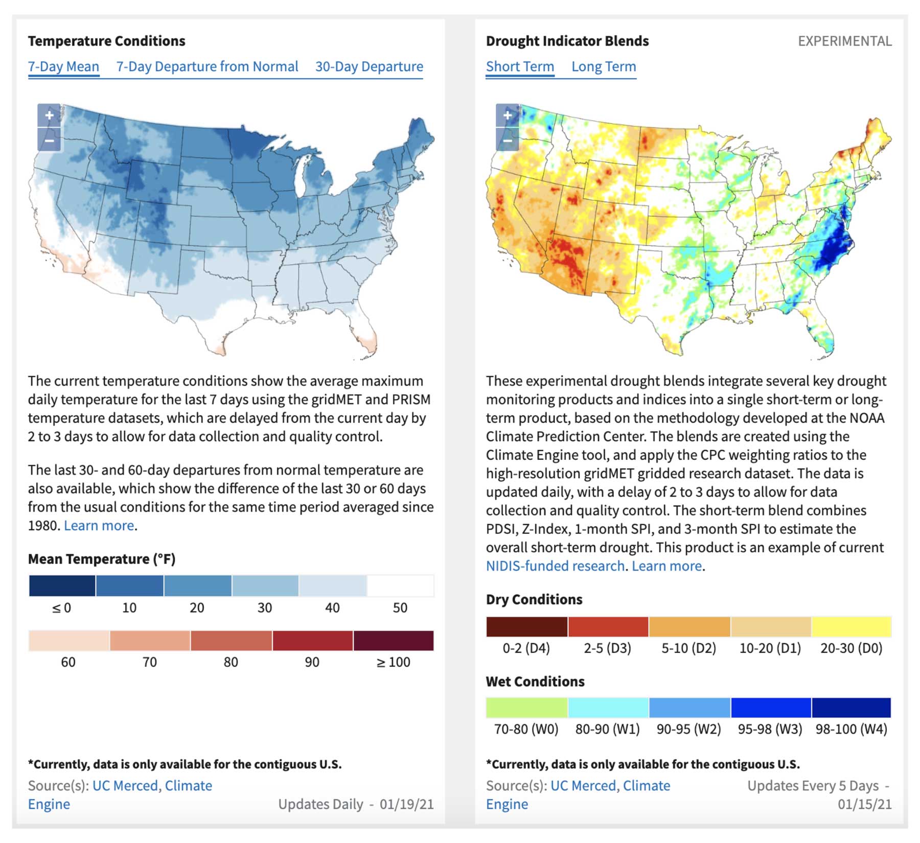
Figure 1: Current temperature conditions and drought indicator blends that integrate several key drought monitoring products and indices into a single short-term or long-term data product.
Outcomes
NIDIS is now easily accessing one petabyte of cloud storage through Climate Engine. Employees are accessing maps from satellite data in seconds, as compared to the days it previously took to access this information.
Climate Engine’s cloud-based Application Programming Interface (API) facilitates automated and manual queries, mapping and table summaries for drought and early warning indicators to be delivered straight to NOAA scientists. This significantly increases the speed at which monitoring can be accomplished, as well as making it more credible by incorporating additional scientific information, ultimately improving the prediction of, and communication about, drought.
Insights from Climate Engine have recently been published to drought.gov for Drought Indicator Blends, Precipitation Conditions, Temperature Conditions, and Palmer Drought Severity Index (PDSI). Drought Indicator Blends integrates several key drought monitoring products and indices for short and long-term scales to provide a robust product to better understand short and long-term drought in a region. PDSI is a standardized index based on a simplified soil water balance that estimates relative soil moisture conditions. Publishing this data facilitates better tracking of drought indices, as well as better reporting for short and long timeframes. Specific reporting examples include automated drought records processing and information for NOAA’s Annual Climate Reports showing cumulative annual drought data.
Related Stories

Managing Public Lands from Space
Dataset
Landsat NDWI (NIR/SWIR1)
North America • Infrastructure & Transportation
Balkh River, Afghanistan
United States Geological Survey


© 2025 Climate Engine
All rights reserved worldwide.